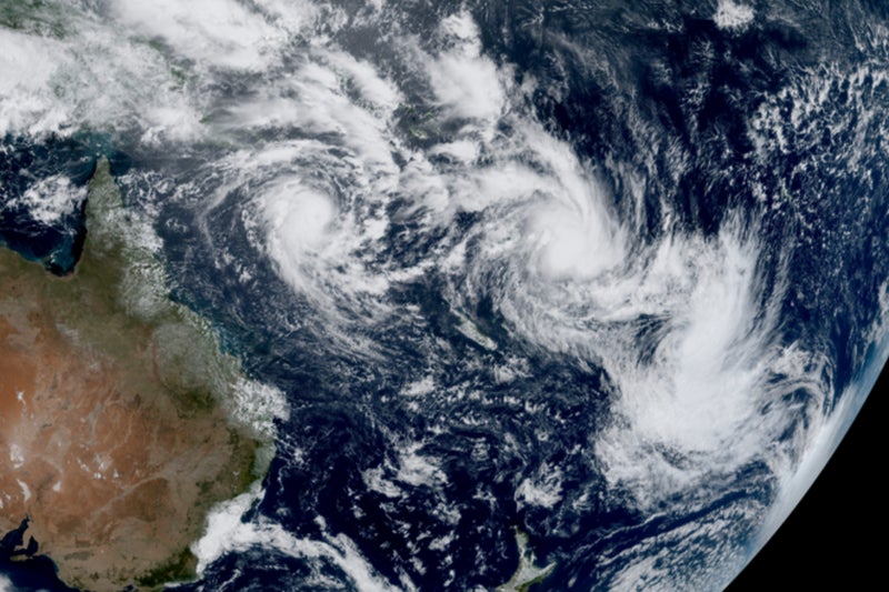
Bianca, Garance and Honde churn across Indian Ocean as Alfred, Rae and Seru spin through south-west Pacific. An uncommon meteorological event unfolded on Tuesday when six named tropical cyclones were active simultaneously in the southern hemisphere, several in close proximity to each other.
Three developed in the south-west Pacific. Severe Tropical Cyclone Alfred formed on 20 February in the Coral Sea to the north-east of Australia, reaching an intensity equivalent to a category-4 hurricane on Thursday with sustained winds of 105mph (170km/h) and gusts at about 140mph.
Alfred is tracking south, moving roughly parallel with the Queensland coast, and warnings have been issued for strong winds and rough seas. Though it is not expected to make landfall, the Australian Bureau of Meteorology is monitoring Alfred as it remains uncertain how close it will pass by the coast.
Farther east in the south-west Pacific, there were two shorter-lived storms, Rae and Seru, which reached a maximum intensity equivalent to a category-2 hurricane. Tropical Cyclone Rae developed just north of Fiji on 22 February before travelling south across the island.
Tropical Cyclone Seru formed on 24 February over the southernmost Solomon Islands, travelling southwards and passing to the east of Vanuatu and New Caledonia. While Seru remained offshore, Rae caused significant damage to some Fijian islands, owing to a combination of flood waters from heavy rain, gusts of about 100mph, and huge waves.
Severe Tropical Cyclone Bianca, which formed in the Timor Sea to the north-west of Australia, was active between 18 and 27 February in the south-east Indian Ocean, during which time it travelled west before veering south, allowing it to curve around the continent without making landfall. This cyclone had a peak intensity the equivalent of a category 3 hurricane.
And in the south-west Indian Ocean, two more cyclones are bracketing Madagascar, both of which developed on Monday. The category 3-equivalent Intense Tropical Cyclone Garance formed to the north-east of Madagascar and travelled south. After passing to the west of Mauritius, Garance will affect the French island of Réunion on Friday, with 120mph gusts and the potential for up to 600mm of rain.
Meanwhile, the category 1-equivalent Severe Tropical Storm Honde formed in the Mozambique channel and travelled south-east, where it is skirting the southern tip of Madagascar. Though infrequent, it is far from unusual for this many named storms to exist concurrently. A far rarer occurrence is for this many to occur within a single ocean basin.